

Over the centuries, France has coined several terms to describe the same need: finding the scale at which one feels at home. Natural region, bioregion, ‘pays’ or ‘bassin de vie’ each tell a different yet complementary story of the same territory, beyond administrative boundaries, encompassing landscape, identity and everyday life.

Ask someone from the Diois region, a winegrower from the Baronnies or a cyclist on the ViaRhôna where they’re from, and you’ll rarely be given the name of an inter-municipal authority or an urban area. Instead, they’ll talk about a commune, a region, a valley or a terroir. This instinct is significant: for over a century, French geography has sought to define this lived-in territory – the one that holds meaning for those who live there.
Beyond the commune – the basis of France’s territorial organisation – four concepts overlap, much like a mille-feuille of French cheeses, to answer this question: the natural region, the bioregion, the ‘pays’ and the catchment area. They do not tell the same story, but they all pose the same question: on what scale do we really live?
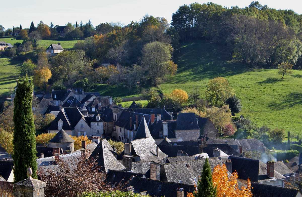
The natural region: the landscape’s imprint
Before prefectures, before administrative maps, there was the land itself: its folds, its valleys, its soils. The natural region is the first serious attempt to understand how a landscape shapes a way of life.
A geography shaped by the landscape, predating administrative maps
We have to go back to the late19th century to find the origins of this concept. A geographer, Paul Vidal de la Blache, travelled the length and breadth of France with a simple yet revolutionary conviction for the time: that the land is not merely a backdrop against which people settle at random. It is a living entity, made up of landforms, climates and soils, which profoundly shapes the ways in which people farm, build, travel and live together. From this insight arose the notion of the ‘natural region’ – a territory whose unity stems primarily from its physical characteristics.
The Paris Basin, with its limestone plateaus and vast cereal-growing plains. The Massif Central, with its high volcanic plateaus and harsh winters. The Rhône Valley, that great north-south corridor where, century after century, the river has shaped trade, agriculture and towns. Each of these regions tells a story in which nature laid down the initial rules of the game, even before humans added their own. This is not an administrative geography. It is a geography of the soil, the climate and the rock – a geography that one could almost read with one’s bare hands, by touching a rammed-earth wall in the Bièvre or a slate slab in the Vivarais.
Names that have stood the test of time
What is striking about these natural regions is their incredible resilience over time. They have never had a prefect, never had a budget, never had a logo. And yet, they are still here. La Beauce, La Bresse, La Sologne, Le Diois, Le Vivarais: these names are still used today in conversation, on wine labels, in tourist guides, and in the place-name registers of the local authorities themselves. Bourg-en-Bresse and Vernoux-en-Vivarais have proudly borne the name of their natural region for centuries, without any law ever having imposed it upon them.
These are names that have survived administrative reforms, the departmental reorganisation of 1790, and the regional reforms of 1972, 1982 and then 2015. They have endured through the centuries because they are not dependent on any authority: they are rooted in the landscape. And the landscape, unlike borders, takes millions of years to take shape, which gives it a resilience that political maps will never possess. Travelling through France’s natural regions is a bit like following these old names as a breadcrumb trail: crossing the Cévennes, part of the Boutières, then moving on to the Haut-Vivarais, without ever encountering a single administrative boundary that exactly matches what one experiences along the way.
Natural regions?
- A concept popularised by Paul Vidal de la Blache* in the late 19th century.
- Based on physical criteria: topography, geology, climate and hydrography.
- Generally limited in extent, ranging from a few tens to a few hundreds of km².
- Notable examples: the Massif Central, comprising Auvergne, Limousin, the Cévennes, Velay and Quercy.
- A concept with no legal existence whatsoever, but one that remains very much alive in place names and local identity.
The bioregion: thinking about the territory through the lens of living organisms
A century later, on the other side of the world, a new generation has taken up the idea of the natural territory, but with an additional ambition: no longer simply to describe the environment, but to learn to live within its limits once again.
An idea that emerged in the 1970s in response to globalisation
The year is 1977, in California. Two Americans, Peter Berg and Raymond Dasmann, published a paper that would quietly make its way over the decades before re-emerging with force in the contemporary environmental debate. Their observation is simple: economic globalisation has severed human societies from their natural environment. In everyday life, people import food from the other side of the world, build without taking the local climate into account, and standardise landscapes.
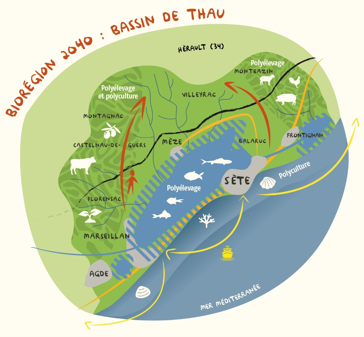
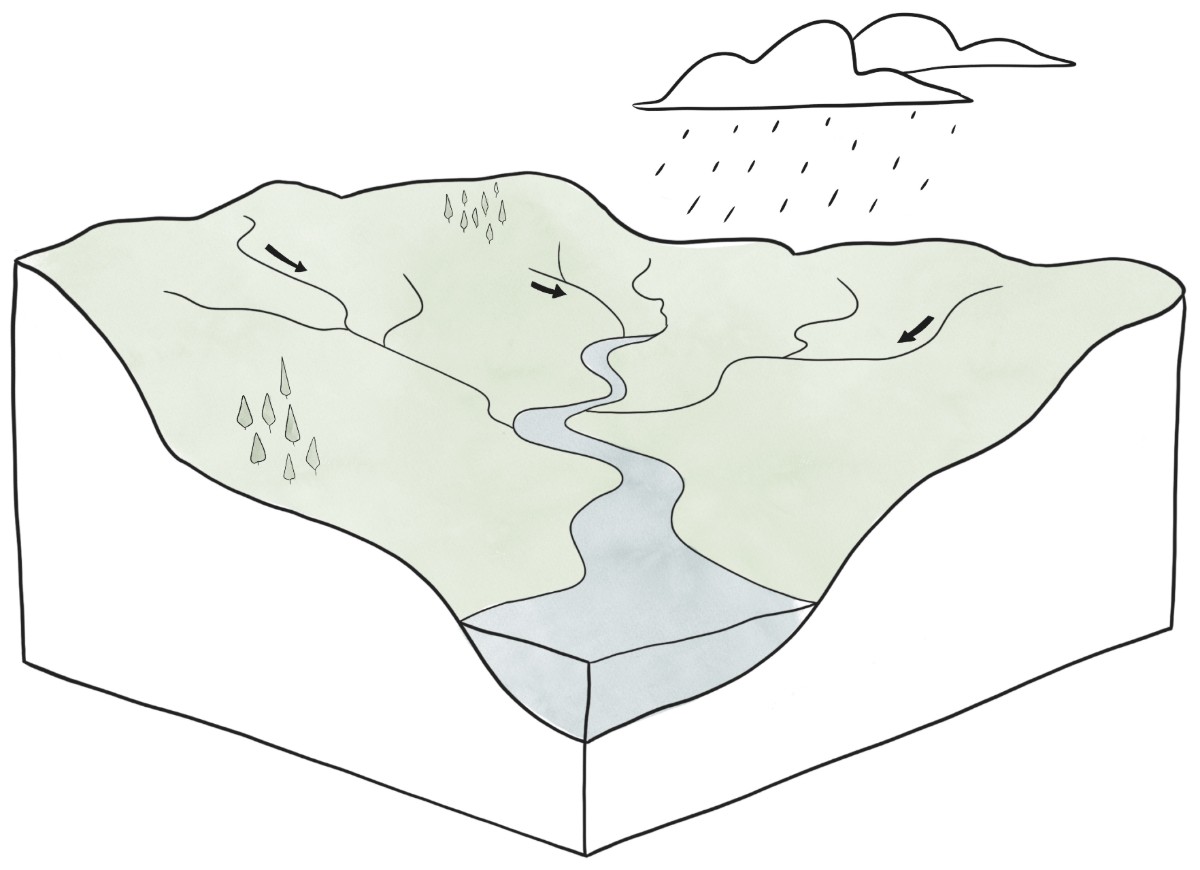
In response to this, they propose an almost defiant concept: the bioregion – a territory defined not by political borders, but by real, cross-cutting ecological continuities: a catchment area, a mountain range, a climate zone, or a biodiversity area.
But the bioregion goes beyond a scientific description of the environment. It adds a dimension that the natural region lacked: the awareness and will of the inhabitants. For Berg and Dasmann, it is the people living in a given area who are best placed to sense its true boundaries, far better than a satellite or an administrative map. The bioregion is therefore defined both by the land itself and by the perspective of those who inhabit it, like a hymn to local democracy in its geographical reality.
Living within the boundaries of a catchment area or a mountain range
Whereas a natural region tells the story of a heritage – what the landscape has shaped over time – a bioregion embodies a forward-looking vision: that of greater food, energy and social self-sufficiency, rooted in a territory’s actual capabilities. Living within the boundaries of a biologically defined territory means, for example, planning one’s agriculture, water use and transport based on locally available resources, rather than on a global market that is indifferent to the local context.
In France, this idea is still largely championed by citizens’ groups, associations and alternative local initiatives, rather than by the state. Some groups organise themselves around a mountain range, others around a specific catchment area – such as that of the Eyrieux in the Ardèche, for example – where there is a strong geographical coherence between the wooded hills, the agricultural valleys and water uses. It is not yet a structured public policy in the same way as the zoning of ‘living basins’, but it is a way of thinking about the territory that is increasingly shaping debates on the ecological transition, local food systems and resilience to droughts and floods.
Bioregion?
- A concept formulated by Peter Berg and Raymond Dasmann in 1977, in California.
- Ecological basis: catchment area, mountain range, climate, biodiversity.
- A strong participatory element: local residents help to define its boundaries.
- Stated objective: self-sufficiency and resilience in the face of environmental crises.
- A concept that is still not widely institutionalised in France, driven mainly by citizens’ groups.
The country: an identity before it is a piece of legislation
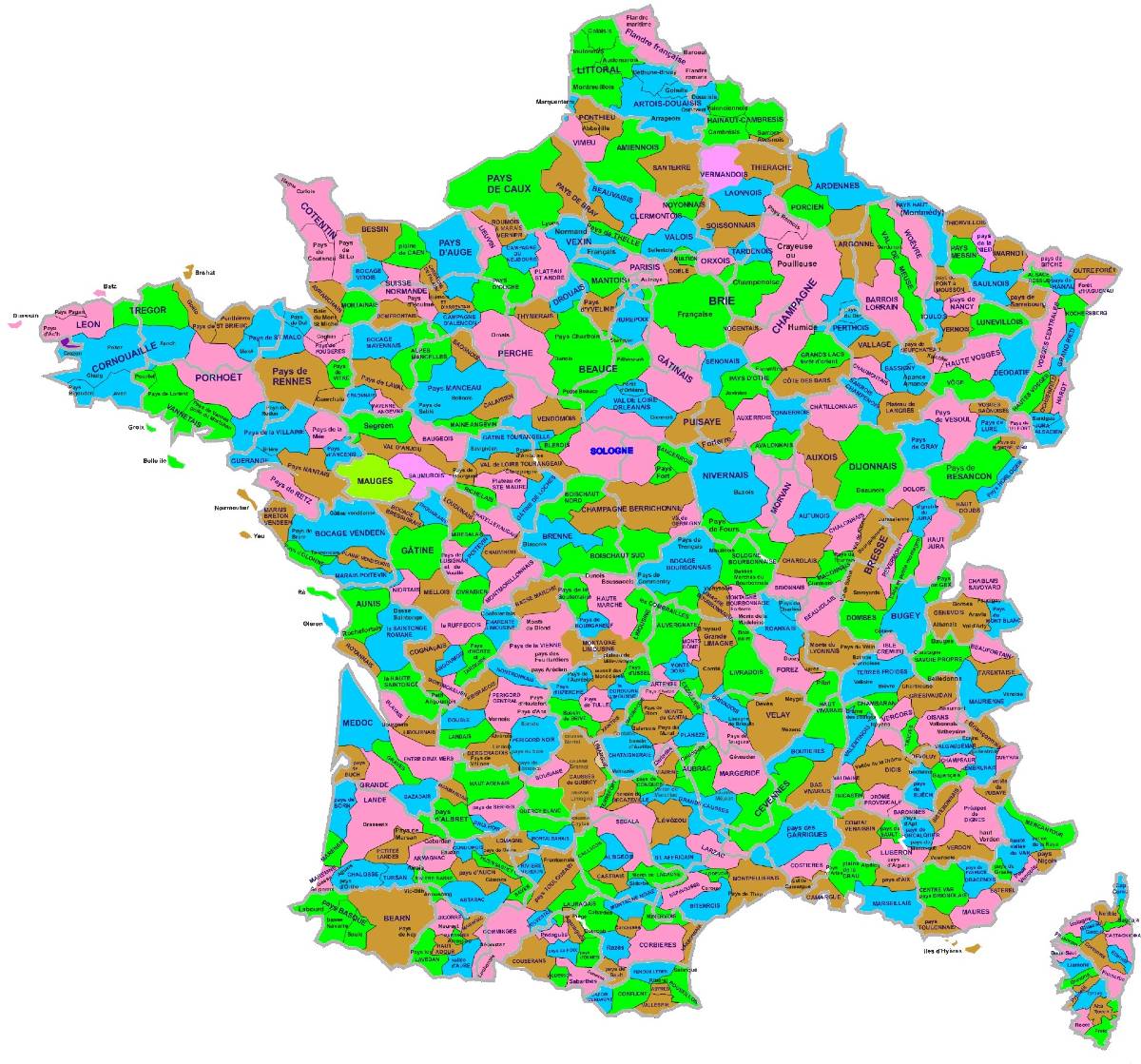
Long before the introduction of land-use planning legislation, the word ‘pays’ was already used to express a sense of attachment, an identity, a way of being ‘from here’ rather than ‘from elsewhere’. It was not until the end of the20th century that a piece of legislation attempted, with limited success, to transform this sentiment into a tool for public policy. The term ‘pays’ is also frequently found in the names of inter-municipal bodies (EPCI).
The ancient pagus, the unassuming forerunner of our local identities
The word ‘pays’ has much older origins than one might imagine. It derives from the Latin pagus*, which, even in Roman antiquity, referred to a small rural district organised around a market town. This root has endured through the centuries to give rise to hundreds of traditional French ‘pays’, such as the Pays de Caux in Normandy, the Pays d’Auge, the Basque Country and the Pays de Gex. These territories have never needed a law to exist: they have established themselves through the force of custom, passed down from generation to generation through conversations, fairs, weddings and local rivalries.
Unlike a natural region, a ‘country’ is not primarily defined by physical criteria. It is defined by cultural, historical and sometimes even linguistic cohesion: a particular accent, a way of cooking, a local festival, a shared memory of the events that have shaped the place. It is a geography of belonging rather than of the landscape; a geography that one senses before one can measure it.
From the Pasqua Act to ‘centres of equilibrium’: the turbulent history of a concept
It was the Act of 4 February 1995 on guidelines for spatial planning and development – known as the Pasqua Act – that first introduced the concept of the ‘Pays’ into French law. Article 22 is brief but fundamental: it recognises that a territory exhibiting“geographical, cultural, economic or social cohesion” may be established as a ‘Pays’, on the initiative of the local authorities and their associations. The stated aim is already that of a project-based territory, designed to“express the community of economic and social interests” between the town and the surrounding rural area. It is a law based on voluntary cooperation, without any new binding administrative tier: local elected representatives remain free to decide whether or not to make use of this tool.
Four years later, the Act of 25 June 1999, known as the Voynet Act, brought about changes to this still-experimental framework. It now requires a regional charter, a development council bringing together civil society, businesses, organisations and residents, as well as the option to sign a regional contract with the State and the Region to fund local development initiatives. It was this strengthened version that enjoyed its golden age between 1999 and the mid-2000s: several hundred ‘pays’ sprang up across France, from the ‘Pays de Cornouaille’ in Brittany to the ‘Pays Cathare’ in Occitanie, from the Basque Country to the ‘Pays de la Vallée de la Drôme’, via the ‘Pays des Vosges du Nord’ and the ‘Pays Provence Verte’ in the Var. The Act of 2 July 2003 on town planning and housing then went on to further clarify the purpose and objectives of these ‘pays’, without altering their general spirit.
However, this legal status was brought to an abrupt halt by the local government reform of 16 December 2010, against a backdrop of a general desire to simplify France’s “layered local government structure”. Article 51 of the reform outright repeals Article 22 of the 1995 Act: it becomes impossible to create new ‘pays’, although existing structures and contracts already signed continue to be honoured until their expiry. For four years, the existing ‘pays’ thus found themselves in a sort of legal limbo, tolerated but without a solid legal basis, before being removed from the legal framework.
The rest of the story is almost a rehabilitation, but without the momentum of the previous phase.
The MAPTAM Act of 27 January 2014*, designed in particular to reassure rural communities in the face of the growing influence of metropolitan areas, creates a new instrument directly inspired by the ‘pays’: the territorial and rural balance cluster, or PETR. This new joint authority, which brings together several inter-municipal bodies around a shared territorial project, enables many former ‘pays’ to regain legal status by transforming themselves. This is how the ‘Pays du Diois’ and the ‘Pays de la Vallée de la Drôme’ were able to continue their work in this new form, as were dozens of other territories across France, from the ‘Pays Yonnais’ in Vendée to the ‘Pays Vidourle-Camargue’ in the Gard.
The NOTRe Act of 2015, by refocusing public action on larger inter-municipal bodies, has effectively eroded the spirit of the ‘pays’ within an institutional landscape largely dominated by inter-municipal cooperation, without, however, causing the PETRs to disappear entirely. Some remain active today, implementing territorial coherence plans or local development policies across several combined catchment areas.
The term ‘Pays’ therefore survives today in two quite distinct contexts: a low-key institutional context, through the PETRs which have taken over its remit, and a much more vibrant popular and tourist context, where people continue to refer to the Pays d’Auge, the Basque Country or the Diois region far more readily than of the administrative structure which, technically speaking through the inter-municipal bodies (EPCI), has taken over from it.
Which countries?
- Etymological origin: the Roman pagus*, the precursor to our traditional regions.
- In 1995, the Pasqua Act (Article 22 of the LOADT) legally established the concept of ‘country’.
- In 1999, the Voynet Act strengthened the framework with regional charters, development councils and regional contracts.
- Legal criterion applied: geographical, cultural, economic or social coherence.
- Between 1999 and 2005, several hundred villages were established across France.
- In 2010, the local government reform repealed the legal basis for the ‘pays’ and prevented the creation of new ones.
- In 2014, the MAPTAM Act established the Territorial and Rural Balance Clusters (PETRs), which took over the role of the former ‘pays’.
- Since 2015, the concept has gradually been superseded by inter-municipal cooperation following the NOTRe Act of 2015.
The catchment area: the territory of everyday life
After the landscape, community life and memory, there remained one final question, the most down-to-earth of all: where do you actually go, every day, to see a doctor, do your shopping or take your children to school? It is this very simple question that gave rise to the most recent concept – and, paradoxically, the one most widely used today by public authorities – the ‘catchment area’.
A new concept developed by INSEE to measure access to services
The catchment area has neither the historical depth of the country nor the symbolic significance of the bioregion. It is a tool born out of the very practical need to measure and organise public and private services across the territory. INSEE defines it as the smallest area within which residents have access to the most common facilities and services: food shops, schools, healthcare professionals, postal services and employment. When delineating it, statisticians do not take into account either the terrain or cultural identity, but rather the actual movements of residents – which town do they actually travel to in order to find a doctor, a secondary school or a supermarket?
This approach is almost the opposite of that taken with regard to a natural region or a country: rather than using heritage as a starting point for understanding the present, it begins with an observation of the present in order to define a scope for action. It is a form of geography free from nostalgia, focused entirely on efficiency and equitable access to services, based on statistical data.
1,707 living areas that are reshaping the map of France
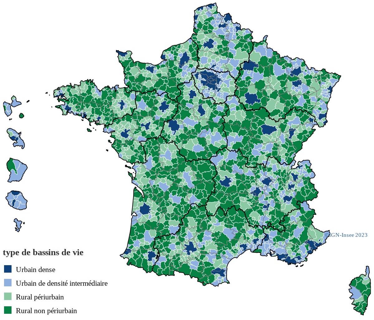
The latest update to this zoning scheme, published in 2022, identifies 1,707 local catchment areas across the whole of France, the vast majority of which are located in rural areas. Each of these catchment areas is organised around a service hub: a medium-sized town, a market town, or sometimes a simple rural commune which provides most of the facilities for the surrounding villages. This classification, which is updated regularly, now serves as an essential reference for numerous public policies: the establishment of new health services, the redefinition of school catchment areas, territorial assessments for rural development contracts, and the identification of areas to be revitalised as a priority.
This is undoubtedly the most practically applicable concept of the four: a mayor, a prefect, a local policy officer or a project leader can draw directly on catchment area data to justify opening a shop or a health centre, or closing a school class. Unlike the ‘country’ or the ‘bioregion’, the catchment area carries no particular identity-related or ecological connotations, but it is precisely this relative neutrality that makes it such a valuable working tool for local authorities.
Habitat basins?
- A concept defined and updated by INSEE; latest version from 2022.
- Delimitation criterion: access to the most common facilities and services.
- 1,707 catchment areas were recorded in mainland France in 2022.
- A large majority of them are located in rural areas.
- A central statistical reference for policies on the planning and organisation of public services.
Four grids, one territory
At the end of this journey through four concepts that emerged in different eras, one thing becomes clear: natural region, bioregion, country and living area are not rivals seeking to assert themselves over one another. They are four lenses focused on the same space, each shedding light on a different dimension of what it means to live in a territory. The natural region tells the story of the terrain that has shaped the landscapes over millennia. The bioregion invites us to relearn how to live within the limits of the living world. The ‘pays’ carries the memory and sense of belonging passed down from generation to generation, through a turbulent and chaotic administrative history. Finally, the ‘bassin de vie’ organises access to everyday services in very practical terms, but without taking natural considerations into account.
To understand a destination in one of France’s regions often means superimposing these four perspectives without even realising it: travelling through landscapes shaped by millions of years of geological processes, following a catchment area that shapes the water system and local agriculture, through a region steeped in history and with a distinct tourist identity, whilst passing through villages that form part of very real local communities, complete with their chemist’s, their school and their Saturday morning market. Far from being at odds with one another, these four perspectives together paint a more accurate, more vivid picture of what it really means to be from here, to live there and to travel there.
And to continue our discussion on the subject of the regions of France, I invite you to watch this video, which outlines the history of how territorial divisions have evolved, with one question in mind: what if we were to rethink administrative divisions based on natural regions?
Travel+
- Map of France’s Countries and Natural Regions
- How can we reduce the costs of the multi-layered local government structure?Public Life↗
- Paul Vidal de La Blache,Wikipedia↗
- Bioregions: an ecological alternative to administrative regions,Reporterre↗
- Bioregions: an alternative form of geography that is more respectful of life, LaRelève↗
- Designing a bioregion? EGUP Collective
- Pagus,Wikipedia↗
- Law and Country in France:1995↗,1999↗,2010↗,2014↗,2015↗ via Wikipedia and Vie Publique
- 2022 Living Area Database, INSEE1↗ and2↗